


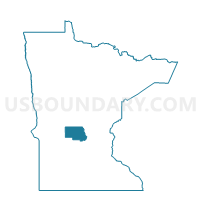
Farming Twp. Voting District, Stearns County, Minnesota
About
Outline

Summary
| Unique Area Identifier | 604438 |
| Name | Farming Twp. Voting District |
| County | Stearns County |
| State | Minnesota |
| Area (square miles) | 38.93 |
| Land Area (square miles) | 37.61 |
| Water Area (square miles) | 1.32 |
| % of Land Area | 96.60 |
| % of Water Area | 3.40 |
| Latitude of the Internal Point | 45.54670570 |
| Longtitude of the Internal Point | -94.57157790 |
Maps


Graphs
Select a template below for downloading or customizing gragh for Farming Twp. Voting District, Stearns County, Minnesota


Neighbors
Neighoring Voting District (by Name) Neighboring Voting District on the Map
- Albany Twp. Voting District, Stearns County, MN
- Avon Twp. Voting District, Stearns County, MN
- Collegeville Twp. P-1, Stearns County, MN
- Munson Twp. Voting District, Stearns County, MN
- St. Martin Twp. Voting District, Stearns County, MN
- Wakefield Twp. Voting District, Stearns County, MN
- Zion Twp. P-1, Stearns County, MN
Top 10 Neighboring County Subdivision (by Population) Neighboring County Subdivision on the Map
- Collegeville township, Stearns County, MN (3,343)
- Wakefield township, Stearns County, MN (2,756)
- Avon township, Stearns County, MN (2,294)
- Munson township, Stearns County, MN (1,466)
- Farming township, Stearns County, MN (987)
- Albany township, Stearns County, MN (980)
- St. Martin township, Stearns County, MN (545)
- Zion township, Stearns County, MN (335)
Top 10 Neighboring Unified School District (by Population) Neighboring Unified School District on the Map
- Rocori Public School District, MN (12,663)
- Albany Public School District, MN (8,870)
- Paynesville Public School District, MN (6,164)
Top 10 Neighboring State Legislative District Lower Chamber (by Population) Neighboring State Legislative District Lower Chamber on the Map
Top 10 Neighboring State Legislative District Upper Chamber (by Population) Neighboring State Legislative District Upper Chamber on the Map
Top 10 Neighboring 111th Congressional District (by Population) Neighboring 111th Congressional District on the Map
Top 10 Neighboring Census Tract (by Population) Neighboring Census Tract on the Map
- Census Tract 111, Stearns County, MN (7,042)
- Census Tract 113.04, Stearns County, MN (6,321)
- Census Tract 104.02, Stearns County, MN (3,947)
- Census Tract 104.01, Stearns County, MN (3,759)